Monday, 27 June 2022

Bird report June 2022

Life is about to get a bit frantic for me with Census results coming out tomorrow.  So I am a day or two early with the June Report.  As usual:

  1. I will update the report if any exciting sightings come to my notice (that has happened with receipt of a list from Gabo Island adding 4 species to the month list): and
  2. Very much as usual; after nearly drafting this report I recorded an additional species (Little Grassbird) so have already had to act on point 1!

Overall a good diversity of birds were reported this month, with 131taxa listed across the District.  I suspect the list would have been longer had a planned pelagic from Eden into Victorian waters gone ahead: in view of the weather a very sensible decision to pull the pin.  By way of balance, a tour group did visit for a period spanning late May and early June and added a number of less common species to the list.

A total list of species is here.  In summary we did somewhat better than May 2021 and recorded more species than June 2021.

I don't rate any species as a "rip your shirt off" exciting observation for this month, but nice-to-see sightings include:
  • Brown Quail: a covey of 6 at Shipwreck Creek;
  • Buff-banded Rail and Black-shouldered Kite from Gabo are both infrequently reported in the area.
  • Hoary-headed Grebe: still in relatively small numbers but a raft of 52 birds were seen in Double Creek Arm on 25 June.  It is normal to see a few of this species in the Inlet in Winter, but that is an unusually large aggregation away from the WWTP.
  • Nankeen Night-Heron is back to being seen regularly in the Pittosporums at Bucklands.
  • Striated Heron 1-2 birds continue to be reported from a range of sites, mainly in and near Coulls Inlet.
  • Pied Cormorant is relatively uncommon, so good to see 3 resting on floating vegetation off Seagull Island on 25 June.
  • Very exciting to get reports of both Sooty Owl and Barn Owl (neither seen by me 😡).
  • Glossy Black-Cockatoo and Ground Parrot are two of our specials!
  • Southern Emuwren was only reported once but from a location where not previously reported since the fire. I shall do a special report on the species when I have downloaded the data for the first half of 2022.
  • Tawny-crowned Honeyeater is another 'Mallacoota special' and reported from both the Gun Club and Shipwreck Creek.
  • Flame Robin was rarely reported in the area until seen on a COG trip in 2021. The species now seems to regular around the airstrip in Winter.
  • Beautiful Firetail was reported a couple of times from Shipwreck Creek (not seen by me 😡).
A couple of Missing In Actions:
  • Hooded Plover has not been reported for a couple of months, presumably due to rough weather affecting their usual sites.
  • Bassian Thrush has not been sighted this month. (😡, or worse.)

Categories

We have done well on Waterbirds and most Passerines.  We have done less well on:
Waders: There have been plenty of Bar-tailed Godwits and Red-capped Plovers on the sandbars near the mouth but few other waders.  Perhaps they are up on the Goodwin Sands - I could see a number of wader "shapes" when looking down from Angophora Drive with my telescope but at ~2.5km range couldn't try to guess the species.
Seabirds: A few species have come within ID range but most have been well out to sea.  Refer to comments above about pelagic outing.

Conservation Status

A sheet in the linked Google Sheet summarise the conservation status of the species recorded.  We had 3 species of concern at the National level and a further 6 of concern at the Victorian level.

Breeding Activity

Although we still have some weeks of Winter to endure the birds are beginning to move towards breeding. The specific records I have noted are:
  • Whistling Kites carrying nesting material to the Angophoras near our house; and
  • Masked Lapwings having at least 3 eggs in a nest on our neighbour's lawn.
We have relocated 19 of the 20 nest boxes erected at the Bunker Museum and look forward to seeing birds starting to use them as the season advances.

Birdlife topics

In recent months Mallacoota birders have participated in Birdlife Australia projects on Glossy Black Cockatoos and Australian Pelicans.  The summary results of this appeared in The Chat and I have copied a snip below.
The results of the pelican count are explicitly given in the poster.  As far as I am aware no-one found any Glossies in the Mallacoota area but there were feed trees identified.


Sunday, 26 June 2022

Meanderings and sky watching

This covers a few walks and sunrises and sunsets in late June 2020. 

The first image is of a late stage of sunrise on 23 June.  The usual sunrise over the Howe Range wasn't too exciting but the glowing clouds looking North (note Mt Imlay on the horizon) were pretty spectacular.

Our main activity for the day was the heathland walk.  It not only covers the Davis Creek heath but a chunk of beach and the Chip Track.
The first element of the walk, from Betka Rd down to Davis Creek was well chopped up by recent weather.
The beach showed that the large swells of the previous week had cut back into the dune.  This bank is about 1.8 m (6 feet in old money) high.
The erosion was particularly evident at the mouth of the Betka.  Hopefully the sand will build up again to make a happy nesting site for the Hoodies.
I took a fe photos of the early flowers on the way back.  Dillwynnia sericea.
Acacia suavolens
Acacia myrtifolia
Acacia terminalis
Correa reflexa
Two colours of Epacris impressa.

Sunset on the 23rd.
We have been aware of the carnal proclivities of 'our' pair of Masked Lapwings over the last few weeks.  That has led to the expected outcome of a nest set up on our neighbour's lawn.
Sunset on the 24th.

Sunrise on 25th with silhouetted Blackbird.
I went for a walk to Double Creek in the afternoon of 25th.  The contractors have done a pretty good job of rehabilitating the Nature Trail.
On the upper part of the trail there is one tree labelled as a Cherry Ballart.  I think John Cleese and Michael Palin could well have a discussion, a la Norwegian Blue Parrot about the viability of this tree!  
I crossed Genoa Rd to wander out to the Lake.  It was very still, as shown by this snap of Double Creek.  The walk was relatively dry, with on a couple of soggy areas.
There were not a great number or diversity of birds around on either of these walks so I thought I would go and check the Broome St Lagoon and Seagull Island before going home.  The highlight was 3 Pied Cormorants (the big jobs) sitting on a floating log!
Sunset on the 25 th was rather spiffy.


Tuesday, 21 June 2022

Measuring wasn't meant to be easy

When Medium Sized Mal (Fraser - the only Big Mal around is Meninga) said "Life wasn't meant to be easy." he was probably not thinking of trying to estimate the width of the mouth of Mallacoota Inlet.  It is however not an easy task without a good range finder.

The first estimate of the width was by Michael York who offered 100 m.  His difficulty was finding someone to hold the other end of the tape measure.  

I had a crack on June 20, taking compass bearings from a couple of spots on the Western side of the Inlet to a lump of seaweed on the Eastern side and plotting all this on Google Earth.  All a little dodgy, but gave an estimate of 130 m.  I think it was close to high tide.

My first effort on 21 June was from Captain Stevenson's Point.  That was not possible as there was very difference in compass bearing to the Western and Eastern sides of the mouth.  So I had another go from the lookout at the far end of the Campground.

I took my bearing to the end of the sand spit on the left of this image and a point on the right hand side as close to directly opposite this as I could estimate.  From the image it is very clear that the tide is quite low (and that the water depth is very low for about half the width).
I plotted the position of the lookout and the two bearings on Google Earth.  The two big clumps of shrubbery inside the SSE line of this image no longer exist (well, not in that position: I think they are now somewhere near the wharf).  The Mal-ific  difficulty here is that for precision it is necessary to know how far along the lines the actual mouth is situated.  My guess is represented by the green line: this is 120 m long.  A line joining the two pins is 140 m long and it was a good bit closer to my position than that.
Trying to bring all this together I think I would say that the width of the water varies from about 120 m at low tide to 140m at high tide.  Noting the area of shoaling in the second image above I'd suggest that the usable width would be somewhat less than half that at high tide and a lot less at low tide: possibly a jet-boat would be helpful! 


Happy Solstice!

 Mr Sun was pretty happy, or at least pretty, when he rose this morning.  Possibly the colour lasted 5 minutes, just enough to get up the road and take some snaps.


Sunday, 19 June 2022

Who has stolen Bastion Beach?

 I went for a stroll to Bastion Beach on 18 June (at about mid-tide) to check what the big swells had done while we were away.  I had got some idea by walking down the pumping station track on the 17th: clearly the water level at the beach end had been well above normal, having knocked quite a few planks out of the boardwalk.

In summary a lot of sand has disappeared from the beach. This first image shows the wash lapping at the bottom of the steps, just after a swell had broken.  Between breaks the water would be out of this frame.

To get onto the beach, with some certainty of keeping my shoes dry, I had to clamber across the rocks to the right of the steps.  In recent times the usual level of the sand has been to the bottom of the second vertical pole.  Perhaps a metre higher,
The next image shows the length - if that is the right word - of the beach, and the width of the mouth.  I have seen an estimate of it being 100 m wide and wouldn't argue with that.
The track recorded by eBird shows my walk as ~900m return so probably 400m from the steps to the mouth.
The background offered by eBird dates from sometime in the recent(ish) past, but clearly the mouth has moved at least 600m towards the steps.  There are a few comments on various Facebook posts recording how it has shuffled back and forth over the last few decades - from the base of the steps to Harrison's Channel and back again.

The next image is a snip from the above zooming in on my track.
The light blue dashed line is the approximate edge of the water when I was there.  The dashed green line is a tide mark of debris and weed which I think marks the recent high water  mark in Develings Inlet.  The next image shows where the waves have thrown seaweed etc over the beach near the steps.
The red arrow indicates an area where the sea had been breaking over the beach: if that had been sustained it would have taken another 100m off the beach.  Here is the (near) cut through: note all the flotsam at the end of the sand.
After this walk I drove past the mouth of the Betka River.  The entire sandbar on which the Hoodies used to nest has been washed away with a vertical face to the dunes.  
A close up of the remains of the dune.
My guess would be at least a metre of sand has vanished.

Sunday, 12 June 2022

Winter begins in June

 The weather has been a little ordinary recently.  The average temperature was been below normal since the start of the month. This is shown by plotting the 'anomaly'  given by the observed average temperature month to date minus the long term average for the same period.

This could be expected from looking at the daily extremes.

The other notable factor recently has been the wind.  Maximum hourly gusts have been well above 30 kph since 3 pm yesterday, peaking at 53.1 kph at 0100 hrs this morning (12 June).  That is the 33rd highest gust recorded (out of ~28,000 hourly observations).

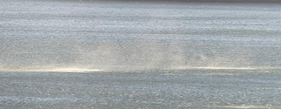
This had the unusual effect of generating circles of spray across the lake.


Later in the evening the Western sky was interesting.


Saturday, 11 June 2022

A few bird photos

 This is for the benefit of followers of this blog who are also in  the Mallacoota Birds Facebook Group, where the snaps originally appeared.

I wondered if there might be a bonus Knot (Red or Great, either would have done) visible from Captain Stevenson's Point on the morning of 10 June. Nope.

My gast was however flabbered by a flock of 8 Caspian Terns on a wee sandbar.

I usually only see 1 or 2 at once (occasionally 3). There is an eBird record of 15 of this species on the Goodwin Sands in November 2020, with breeding behaviour (Feeding Young) noted. The biggest count in eBird for East Gippsland (note, not just the Mallacoota District) is 40 birds recorded in January 2020 on a 5km survey of Lake Tyers Beach. The distribution of #birds per survey shows the prevalence of counts of 1 or 2.
I wondered where the Crested Terns were and found 58 of them (plus one White-fronted) on the sandbar indicated by yellow arrows. I then looked up a tad and found the bunch with red arrow, conservatively estimated at about 150.
Then my oozle was bambed by finding a Sacred Kingfisher!
What on earth is one of them doing in Mallacoota at this time of year? EBird has one previous June record for East Gippsland but none for July.